Salesforce Maps shows your Salesforce records on an interactive map and helps field teams plan their day. A rep can see every school due for a visit, build the shortest route and check in when they arrive. As a result, less time is spent driving and more time selling.
This post builds on Enterprise Territory Management and Salesforce Mobile App setup. We will set it up for the Bright Path Tutors school visit team.
What is Salesforce Maps?
Salesforce Maps is a location intelligence product, formerly called MapAnything. It plots records like accounts, leads and custom objects on a map using their addresses. It adds routing, scheduling, check-ins and, with add-ons, territory planning and live tracking.
Think of it like a delivery app for your sales team. It shows where every stop is, suggests the best order and records when each stop is done.
Why Salesforce Maps Matters
Field reps waste hours on poor routes and missed nearby customers. Managers also cannot see where effort goes. Lists and reports do not show location patterns.
So Salesforce Maps turns location into a planning tool. Reps visit more customers per day, and managers balance territories with real geography.
How Salesforce Maps Works
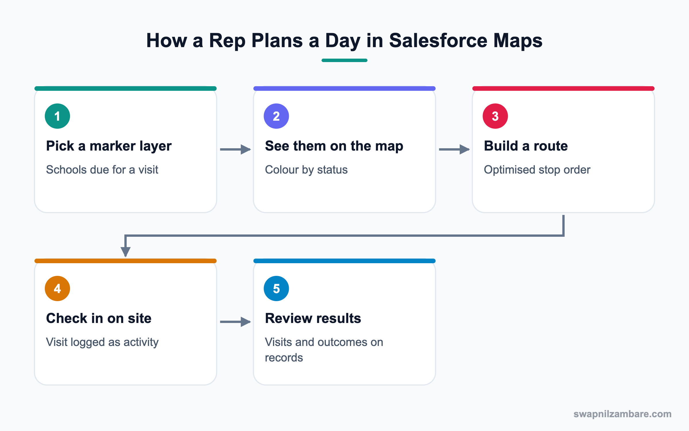
An admin installs Salesforce Maps and assigns permission sets. Then they configure base objects, which tell Maps which objects and address fields to plot. Records are geocoded into latitude and longitude. Finally, users build marker layers, routes and schedules.
Base Objects
A base object links Maps to a Salesforce object and its address fields, such as Account billing address.
Geocoding
Geocoding turns addresses into map coordinates. Clean addresses give accurate pins.
Marker Layers
A marker layer is a saved filter shown on the map, like “Schools not visited in 60 days”. Markers can be coloured by a field.
Data Layers
Data layers shade areas by data, such as population or postal regions, depending on your license.
Routes and Schedules
Users add stops and Maps orders them for the shortest drive. Schedules can plan multiple days with time windows.
Check-In and Check-Out
On mobile, reps check in and out at a stop. Maps logs the visit as an activity on the record.
Territory Planning
The Territory Planning add-on helps draw and balance territories by workload or revenue.
Key Salesforce Maps Features
This table lists the core features and their use.
| Feature | What it does | Bright Path example |
|---|---|---|
| Base object | Connects object to map | Account billing address |
| Marker layer | Shows filtered records | Schools due a visit |
| Colour rules | Colours pins by field | Green for active partner |
| Route | Orders stops | Six school visits today |
| Check-in | Logs a visit | Visit recorded at 11:05 |
| Territory Planning | Balances areas | Equal schools per rep |
Salesforce Maps vs Territory Management
These two are often used together but do different jobs. This table compares them.
| Feature | Salesforce Maps | Enterprise Territory Management |
|---|---|---|
| Focus | Location and routes | Ownership and access |
| Users | Reps and managers | Admins and sales ops |
| Output | Maps, routes, visits | Territories and assignments |
| License | Maps license | Included in Sales Cloud editions |
| Works on mobile | Yes | Mainly desktop setup |
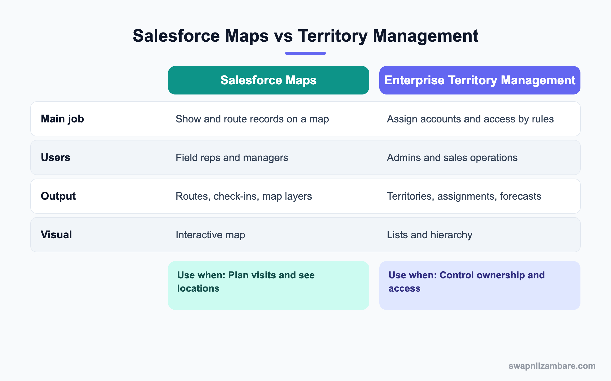
In short, territory management decides who owns what. Salesforce Maps shows where things are and how to reach them.
A Real Salesforce Maps Example
Bright Path has four reps who visit schools in Pune. Each rep should visit schools not seen in 60 days, in the shortest route.
Step 1: Install and Assign
- Install Salesforce Maps from the provided package link or setup page.
- Assign the Salesforce Maps permission set and license to the four reps and their manager.
- Assign the admin permission set to the Maps admin.
Step 2: Configure the Base Object
These are the base object settings used.
| Setting | Value |
|---|---|
| Object | Account |
| Address fields | Billing Street, City, State, Postal Code |
| Tooltip fields | School Name, Last Visit Date, Owner |
| Geocoding | Automatic on save |
Step 3: Build a Marker Layer
- Open Salesforce Maps and click Create Marker Layer.
- Choose Account and add the filter Last Visit Date older than 60 days and City equals Pune.
- Colour markers by Partner Status.
- Save the layer and share it with the sales team.
Step 4: Plan and Check In
- Each rep selects six nearby markers and clicks Add to Route.
- They click Optimize to order the stops.
- On the mobile app, they check in at each school.
- The manager reviews visits in a report the next morning.
Admins can confirm geocoding with a query on the address fields.
SELECT Name, BillingCity, BillingLatitude, BillingLongitude
FROM Account
WHERE BillingCity = 'Pune'
AND BillingLatitude = null
Records in the result have no coordinates, so their addresses need fixing.
Common Mistakes with Salesforce Maps
- Plotting messy addresses, which places pins in the wrong city.
- Building one huge layer with every record, which is slow.
- Forgetting to give users the Maps license and permission sets.
- Not training reps on check-in, so visits are not logged.
- Using Maps for ownership rules instead of territory management.
Best Practices for Salesforce Maps
- Clean addresses with State and Country Picklists first.
- Create small, purposeful marker layers.
- Share standard layers so everyone uses the same view.
- Use check-ins to build reliable visit history.
- Review routes and visits weekly with managers.
Practice Task
List three marker layers your field team would use every week. For each, write the filter and colour rule. Hint: think about last visit date, status and value.
Most Asked Salesforce Maps Interview Questions
These Salesforce Maps questions come up in Sales Cloud and field sales interviews.
Basic Salesforce Maps Interview Questions
Q1: What is Salesforce Maps?
It is a location product that shows Salesforce records on a map and adds routing, scheduling and check-ins.
Q2: What is a base object?
It connects a Salesforce object and its address fields to Maps, so records can be plotted.
Q3: What is geocoding?
It means turning an address into latitude and longitude, so a record can appear as a pin. So if the address is wrong, the pin lands in the wrong place.
Q4: What is a marker layer?
It is a saved, filtered set of records shown on the map, often coloured by a field. For example, green pins for active partners and red pins for overdue visits.
Q5: Can reps use Maps on mobile?
Yes. Reps can view layers, follow routes and check in from the mobile app.
Q6: What does check-in do?
It logs a visit at a stop as an activity on the record.
Q7: Is Salesforce Maps included with Sales Cloud?
No. It needs a separate Maps license, and some features need advanced add-ons.
Intermediate Salesforce Maps Interview Questions
Q8: How does route optimisation work?
Users add stops, and Maps orders them to reduce travel time, respecting time windows if set.
Q9: Why do some records not appear on the map?
Their addresses may be missing or invalid, so geocoding failed. Fix the address and save.
Q10: What are tooltip fields?
Fields shown when a user clicks a pin, like name, owner and last visit date.
Q11: What is Territory Planning?
An add-on that helps design and balance territories on the map by workload or value.
Q12: How do managers see field activity?
Through check-in activities, reports and, with advanced licenses, live tracking.
Q13: Can Maps plot custom objects?
Yes, if you configure a base object with address or coordinate fields. Then custom records, like training centres, appear like any account.
Q14: How do you share layers?
Save them in shared folders, so teams use the same layers. As a result, managers and reps talk about the same view in meetings.
Advanced Salesforce Maps Interview Questions
Q15: Scenario: reps say routes are wrong. What do you check?
Check address quality and geocoding results first. Then review route settings like start location.
Q16: How would you balance territories with Maps?
Use Territory Planning to draw areas and compare workload or revenue. Then align with Enterprise Territory Management.
Q17: How do you protect location privacy?
Use live tracking only with clear policy and consent, and limit who can view it.
Q18: Scenario: maps load slowly. What do you change?
Make layers smaller with tighter filters and reduce tooltip fields.
Q19: How does Maps improve forecast accuracy?
Visit history shows real engagement. So managers judge deals with better evidence.
Q20: How would you roll out Maps?
Clean addresses, set base objects, build a few shared layers and train one team first.
Q21: What reports help after rollout?
Visits per rep, accounts not visited and route mileage, if tracked.
Q22: Why combine Maps with State and Country Picklists?
Clean state and country values improve geocoding. So pins land in the right place.
Q23: What data do you need before starting Salesforce Maps?
Clean addresses on the objects you will plot, plus clear fields like last visit date and status. Otherwise, layers and colours will not mean much.
Q24: How do schedules differ from routes?
A route orders stops for one trip. A schedule plans visits over several days with time windows, so it suits weekly planning.
Q25: Can Salesforce Maps help service teams?
Yes. Service and field teams can see cases or work orders on a map. However, Field Service has its own scheduling tools for technicians.
Q26: How do you explain Salesforce Maps value to a sales head?
Show more visits per day and fewer missed accounts near each route. Then share a before and after report from a pilot team.
Q27: What is a common Salesforce Maps adoption problem?
Reps forget to check in, so visit data looks low. Therefore, make check-in part of the daily routine and review it in team meetings.
Official Resources
- Salesforce Help: Salesforce Maps
- Trailhead: Salesforce Maps Basics
- Salesforce Help: Configure Base Objects
Quick Recap
- Salesforce Maps plots records and plans routes for field teams.
- Base objects and geocoding turn addresses into pins.
- Marker layers show filtered records with colour rules.
- Check-ins log visits as activities.
- Territory management decides ownership, while Maps shows location.
What’s Next?
Next, we store huge data volumes with Salesforce Big Objects.